Feeding the screen-time beast with shifting mobile metrics

Feeding the screen-time beast with shifting mobile metrics

There are a lot of helpful hints on modifying desktop dashboards into mobile ones. They tend to focus on altering the layout to be tall and being mindful of finger-based interactions. I feel they forget one critical aspect - users don’t actually want to look at dashboards on a mobile device. Now with that blasphemous statement out of the way, let’s get on to what users on mobile do want, an analytics app that serves up relevant content that is engaging, useful, and quick to digest on the go.

I seem to be in a mood about making the traditional KPI dashboard a bit more modern as well as increase the value to the end user by aiding the understanding of what is critical. If you haven’t already checked out the post on lighting, please do. It focused on lighting effects to draw the users eye to what is critical based on the impact of a KPI’s deviation from a target. In this post, we play with a KPI’s position on a “mobile app” as another method to assist the user in focusing on what is important now!

Read More

Dashboard Drama - From Flat to Fabulous!

Dashboard Drama - From Flat to Fabulous!

If we consider ourselves storytellers of data, then we should always strive to make those stories more engaging. Taking a cue from movies, photography, and stage, lighting can draw attention to the most critical components of a story. Directing focus is often relegated to minor visual cues such as a dot at the end of a sparkline, or an up and down arrow colored by good vs bad.  Instead of being adornment that distracts from the story, this use of “white space”, focuses attention. We hope this lighting technique adds an enhanced user experience by conveying the drama of a KPI’s deviation from the target’s impact on your organization.

Read More

"Off the Grid" - building Lo-Fi dashboards to create use and value

"Off the Grid" - building  Lo-Fi dashboards to create use and value

I recently had the opportunity to help organize and present at the first Tableau “Kenya Day for Data”.  In addition to great talks from powerhouses organizations like the World Food Progamme, and PATH, I ran a hands-on workshop on “How to Build Dashboards of Use and Value”.  What was unusual about the workshop is that it took place entire using flip boards, stickies, and markers, instead of in Tableau.  Without a pixel being pushed by the participants, they were able to walk away ready to build effective and powerful data tools. 

Here is the nitty gritty so you can hold a similar workshop at your local TUG, or office.

Read More

Lighting as an attentive attribute in KPI dashboards

Lighting as an attentive attribute in KPI dashboards

I have been mulling over his technique of using broadly applied atmospheric washes of paint to draw focus and create intensity, and how to apply it to data visualization.  We usually use the attentive attributes of color, size, shape, position, etc. to draw focus in dashboards.  

I have been spending a lot of time pondering the UX of things not related to data viz and asking how to apply those design ideas to visualization work, as with my widget post.  Outside the sphere of data viz, in everything from photography, to video games, and interior design, lighting is a powerful way to draw focus and create emotion.  I wanted a Marks card with a "Lighting" shelf.

Read More

4th and 5th Grade Girls Help #VisualizeNoMalaria

4th and 5th Grade Girls Help #VisualizeNoMalaria

Over the last couple of months, I was fortunate to have the opportunity to meet with the 4th and 5th Grade Girls Club at a San Francisco school and get them excited about all things data visualization and mapping. In a couple lunches and after school workshops we learned about cartography, map construction, and design, built our own outrageously fun custom maps of San Francisco using Mapbox, and finally contributed to the #VisualizeNoMalaria project by tracing buildings for Humanitarian OpenStreetMap.  My presentation for all the lessons, as well as the instructions for the building tracing are below.   My hope is to help data viz and map practitioners to get involved with children in their local schools to inspire the #DataKids of tomorrow.  Get Mapping!

Read More

Consumed - A study of consumptive malaise

Consumed - A study of consumptive malaise

I think of this viz as a dystopian Harold and the Purple Crayon.  Harold had the power to create a world by simply drawing it.  In this viz, my consumptive malaise draws the world around me.  By sifting through the pile, I discover meaning and conflict in the mountain of banal objects that I interact with daily, and ponder why I use so many things.

The idea was simple - to log every “thing” that I used throughout the course of the day and visualize the “pile”.  Then, categorize and group all the things and see what story they tell.

Read More

Make Love Not War - with the Tableau 10.2 Spatial Connector

Make Love Not War - with the Tableau 10.2 Spatial Connector

"War Transposed" takes the coordinates of bombs dropped by the U.S. during the Vietnam War from 1965 to 1973 and moves them to the U.S.

This is not a statement on the right or wrong of the war, but rather an effort to create context and empathy for the destruction that happens duiring conflict.

This is an artistic piece. The data caveats are many.

Read More

3D "Printing" in Mapbox, Alteryx, and Tableau: "I've got big balls!"

3D "Printing" in Mapbox, Alteryx, and Tableau:  "I've got big balls!"

While starting to work on a new viz project, I came up with the idea to create empathy by putting the user inside of a 3D map with the data happening around them like a virtual reality movie.  Yes, the DataBlick crazy-town express train is starting to chug out of the station again.  This post shows some of my initial explorations into jumping in a viz.

Read More

Sensor vs. Simulated IED: Max's Science Fair Project using Tableau for Image Analysis

Sensor vs. Simulated IED:  Max's Science Fair Project using Tableau for Image Analysis

This is a post by Max, Anya's 12-year-old son.  It was his Science / Engineering Fair project where he used Tableau to visualize his results.  Thank you, Adam McCann and Merlijn Buit for your posts on color analysis that were used by Max for this project.

Each year many people die of bombs and other explosive devices. Some examples are the Boston Marathon and the recent bombing in Manhattan. In many modern wars, thousands of soldiers die due to IEDs (Improvised Explosive Devices). In my project, I will use an infrared sensor to find a cell phone (in place of an IED) in different temperature environments. Judging by how easy it is to see the cell phone, we can tell where infrared would work best, as well as where it would not work.  Using this information we can know when to use infrared sensors to save lives.

Read More

The 3D Tableau Full Monty

The 3D Tableau Full Monty

Recently DataBlick had a client project dealing with analyzing parts on a car during manufacturing and transport, and the client wanted something like Noah's Tesla.  We all want a Tesla, right?  Well, now you can have one (in Tableau at least).  In this post, I'll walk you through how to find a 3D model and get it into Tableau.  The next post will show how to trick it out a little bit as well as "explode" parts in a 3D tool before bringing them into Tableau so you can highlight and interact with them on your dashboard.

Read More

X, Y and a bit of Z - Cheater 3D Orthographic Views & Making everything "Spatial"

X, Y and a bit of Z - Cheater 3D Orthographic Views & Making everything "Spatial"

Anya must have pinged me 10 times over the course of the last week asking me questions about rendering 3d cars in Tableau. I figured it must have something to do with curing malaria. My reply was a bit ironic given the fact that I’ve done my own 3d car. I did it for fun though… I don’t like being told I can’t do stuff. it just doesn’t work as part of a production workbook. Well… from a performance standpoint maybe we will get there soon. But for now my suggestion was to pick a good angle and then drive a steamroller over it and just make it into polygons. I really should have seen the next question coming, but she asked how to do that. I was stumped. My best idea was, hire a graphic artist to trace it for you…

Last night she told me she solved it using QGIS… mind explosion! Of course! Why not use mapping software for this? Geography isn’t the only thing spatial. Why shouldn’t you use QGIS to map your car, your plane, the shelves of your supermarket, what have you. I always thought background images were misplaced in Tableau, I wonder if this is what they were thinking when they put it under maps. Latitude and Longitude are just a special name for x and y (or is it the other way around?). Why not hijack Tableau’s mapping capabilities and import your polygons as custom shapes?

I’ve gone to great lengths to hack multiple layers onto maps, so I was excited to hear multi-layered maps will be coming to Tableau, but this opens the door to hacking that feature into all sorts of things. Someone once told me that everything in Tableau is a scatterplot but I’m starting to think maybe everything should be a map. Oh… I am going to crash that Beta so hard!
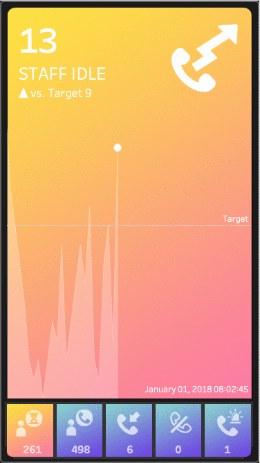
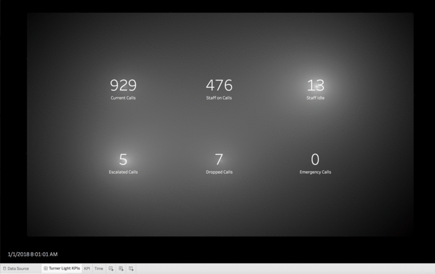
Read More

On the topic of community: & being friends and mentors.

On the topic of community:  & being friends and mentors.

First - sign up and sign up for Emily Kunde's Mentor Match program, and have a chance to win an hour of help with either Allan or Anya as well as other prizes to be announced on Emily's site soon.  

This friendship started with a Tweet:  March 5th, 2014 Tweet to @AllanWalkerIT help…..!  ? "Since you are the king of Tableau Maps, I wanted to see if you had any suggestions?"  For over two years now, we have worked together on many collaborations.   We hope with a quick review of how we have expanded our skills by working together, you can learn from our take-aways and find friends and mentors to work with. 

Read More

A Viz of Many (Gender) Colors

A Viz of Many (Gender) Colors

Pink is for girls and blue is for boys.  How pervasive is this association?

This viz updates live to reflect the crowd voted winning color palette choice.  Tha's right,  this is a live updating Tableau Public viz that uses data from a Google Sheet without needing a web connector!!!!  Thanks to some Allan Walker glitter (which is always black).

Read More

Kids can help #VisualizeNoMalaria!

Kids can help #VisualizeNoMalaria!

Hi, my name is Max. I am eleven years old and I am going into sixth grade.  I LOVE video games and Legos. Yesterday, though instead of playing Minecraft, I volunteered by tracing buildings with my Mom, to help support the fight against Malaria in Zambia.  

I did this because I like to be in the wilderness and go camping and have been bitten by mosquitos many times.  I can’t imagine getting sick or dying from just being bitten by a mosquito and don’t think any kid should worry or suffer from this.

It is really easy to help.  If you want to help too, go this link http://www.tableau.com/about/blog/2016/7/help-visualizenomalaria-56784  and follow the instructions.

Read More

Jonathan Drummey joining DataBlick full time!

Jonathan Drummey joining DataBlick full time!

Last fall, man-about-Tableau Jonathan Drummey (Tableau Zen Master , Tableau Forums Ambassador, leader of the Tableau Healthcare User Group https://community.tableau.com/groups/healthcareTableau blogger, etc.) started working with DataBlick part-time. He’s launched the Help Me DataBlick service and @helpmedatablick Tableau tips tweet stream and has had so much fun he’s joining DataBlick full-time! That’s right!  You can have the amazing Jonathan Drummey work on your project!  Besides project-based work Jonathan is leading our Tableau trainings, with proven, effective coursework tailored to your organizations needs. 

Read More

The New Fabulous Mapbox Studio Tutorial - Making a more Accessible Map

The New Fabulous Mapbox Studio Tutorial -  Making a more Accessible Map

Here is an example of how beautiful your new maps can be.  This one was designed to be a background map that was elegant and provided an alternate to just the black, white, and that other one that no one uses, that come pre-designed in Tableau.   Check it out live and zoom in and out.  Notice the color gradations as you zoom in close.  Those would have taken forever to get right in Classic, not to mention how amazingly smooth it is to zoom in and out and pan around.  This is a map Ferrari!

Read More

Easy Peasy Lemon Squeezy Mapbox Maps and Layers in Tableau 9.2

Easy Peasy Lemon Squeezy Mapbox  Maps and Layers in Tableau 9.2

One of the features that I am most excited about in 9.2 is the ability to add Mapbox map layers from the UI in Tableau instead of having to deal with all the .tms hackery!  If you are a beta tester for 9.2 and are publishing to Tableau Public, this is already available to you to use!  Ready to check out how easy it is now?  I’m going to use my Skyfall themed map to show off how easy it is to add multiple layers, and then we will create a “bog normal view swapper” (a very technical term that Allan Walker seems to use a lot).This will allow the user to change the maps and layers in the background of your published workbook.

Read More